Kaghan & Naran Valleys
 Kaghan valley is one of the prime tourist attractions of Pakistan. Stretched over 160 km, it is abound with snow-clad mountains, flowery meadows, enchanting lakes, and dense forests. With so much to offer, it provides an exhilarating experience; seeked after by thousands of tourists who flock the valley each year.
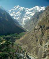
The altitude of the valley ranges from 3000 ft above sea level to it's peak height of 13,690 ft at Babusar Pass. The principle river is the Kunar River which originates from the 11,300 ft Lulusar Lake. Apart from the scenic beauties on offer, the valley is also an attraction for Trout fishing, albeit with a permit. Journey time from the rest of the country to Gilgit and the Northern Areas can be reduced by as much as 4 hours if travelled via Kaghan valley via Babusar instead of the Karakuram Highway via Kohistan. Public transport on this route, however, is scarce and expensive.
 The valley is reachable from Abbottabad and Mansehra via the Karakuram Highway until it forks off to the Kaghan Road. The Kaghan road passes through the splendid forests of Jaaba Pass, with the Kunar river snaking deep below all the way to Balakot. Balakot is the first and most important stop on the way to Kaghan valley. It is located roughly 50 km from Mansehra and is settled o
 n both sides of the Kunar. The site has been venue to a famed battle between Muslims and Sikhs in 1831, where Syed Ahmed Barelvi and Shah Ismail attained martyrdom. Balakot is the supply line to the whole of Kaghan valley and one can find plenty of hotels to stay. The town was completely ravaged in the October 2005 earthquake but is now mostly rebuilt on modern lines. The devastation caused by the earthquake is still visible in many spots.
 The road ahead of Balakot rises straight up to a point where the Kunar seems just a small stream. At a distance of 24 km is the village of Kewai. A small road here leads straight up to the scenic mountain top of Shogran; a total distance of 8 km from the main road. At a height of 7,750 ft, almost all the snow-clad mountains of Kaghan valley are visible from up here. A visit to Shogran would be incomplete without seeing Siri and Paya. Siri; just 6 km from Shogran is reachable via jeep and is home to a beautiful lake and a rest house. 3 km further ahead is the green meadows of Paya; located at a height of 10,101 ft. Paya is actually a portion of the Makra mountain, whose peak is viewable south and has an altitude of 12,745 ft. Paya is also home to a lake. A two hours trek south east of Paya leads to Upper Paya, itself a scenic spot.
 Some 6 km further ahead of Kewai is the small village of Paras. Most public transport stop here for tea and snacks before moving on to Naran. A 16 km jeep-road on the other bank of the Kunar leads to the dense forests and absolute wilderness of Sharan; located at a height of 7,872 ft. Campers seeking absolute isolation usually head here. The only population is that of a forest rest-house and a youth hostel. It is part of the mountain range with Musa Ka Musalla as its peak at 13,372 ft. It is home to a variety of flora and fauna. Apart from different species of birds, it is also home to cheetah's and bears.
Some distance ahead of Paras is the village of Shino; home to a government owned trout fishery and the village of Jarid; famous for its elegant woodcraft. Even farther is the village of Mahandheri where a stream from Munawar valley flows into the Kunar. Walking treks to Darra Munawar Gali, Biyarhi, and Kach Gali originate from Mahandheri. Just a little distance from Mahandheri is the beautiful Pagoda-like Pine Park Hotel at Kunia. The hotel presents a spectacular view especially during night, with its lights reflected eerily in the Kunar River. A jeep track leads to Danna Meadows from here.
 Just 5 km ahead of Kunia is the important town of Kaghan; after which the valley itself is named. The town has plenty of hotels of various variety. Although tourists usually aim to head for Naran, they do stay in Kaghan especially in winters or the start of the tourist season when the road to Naran is blocked due to snow.
 After a scenic drive of 24 km from Kaghan is the town of Naran; located at the centre of the valley. Naran is the final and main destination of tourists who wish to explore the Kaghan Valley. Located at a height of 8,000 ft, the valley is relatively plane and vast. It was also devastated during the October 2005 earthquake and much of it is now newly constructed. Naran is awash with hotels, restaurants, and shops, all neatly arranged on both sides of the Kaghan road. The roar from the gushing waters of Kunar River creates a pleasant atmosphere.
 The next obvious stop of almost every visitor is the famous Saif-ul Malook Lake. At an altitude of 10,547 ft and only 8 km from Naran, the Saif-ul Malook lake has with itself associated many romantic folk tales. It is situated right at the base of the Malka Parbat. At 15,748 ft, Malka Parbat is the highest mountain in the valley whose peak is reflected in the greenish waters of the Lake. A walking trek from here leads to Ansoo lake; named for it's appearance as a tear-drop from an eye. Located at an altitude of 13,583 ft, it was discovered by low flying Pakistan Airforce pilots in 1993. It's existence was not known even to the locals before this time. It can be reached after a one way 5-6 hours trek through a steep climb and a vast glacier. It is also reachable from Biyarhi and Darra Munawar Gali from Mahandheri as previously mentioned. However, the most common route is via Lake Saif-ul Malook. On the main road from Naran is the village of Batta Kandi at a distance of 16 km. Lalazar lake can be reached from here via either jeep or walking trek. Located at 10,500 ft; Lalazar is famous for it's green pastures, butterflies and pleasant atmosphere. It is a safe spot for camping, although hotels are also available. Saif-ul Malook Lake is reachable from Lalazar by a walking trek through Hansgali pass.
 At a distance of 13 km from Batta Kandi is the small town of Barhawi, home to a small guest-house and a few eating joints. Further ahead at a distance of 12 km is Jhalkad, where the Jhalkad stream flows into the Kunar. Here, a small road east leads to Azad Kashmir via Noori Top. The road north of Jhalkad rises sharply and after a dangerous journey, one reaches the barren wilderness of Besal. In contrast to the lush green forests of the Kaghan Valley, Besal offers jagged rocks. A small chaikhaana is open in summers to cater for the needs of travellers. A small road from Besal, passing through tight rocky corridors and deep precipices leads to the Dodipat Lake, referred to as the queen of lakes. This road from Besal to Dodipatsar is only 13 km but takes from 5-6 hours. Some parts of the journey may have to be taken over glaciers. Unique in its own regard, Dodipat Lake is located at an altitude of 12,500 ft. From here, treks lead further to Saral Lake, Saral Gali, and Rati Gali.
 Roughly 2 km from Besal, at a height of 11,300 ft, is the largest and most famous lake of the Kaghan valley; Lake Lulusar. Lulusar is roughly 2.5 km long and is the origin of the Kunar River. In a total wilderness, the lake puts on an eerie silence and uncanny presence. 9 km ahead of Lulusar is the small village of Gitidas, inhabited only in summers by grumpy and inhospitable Chilasi's from the neighbouring Chilas valley. The valley here onwards opens up to the vast Gitidas planes, abound with large patches of greenery and small streams. The 7 lakes of Sat Sur Mala are located east of these planes. After passing through these planes, one reaches the Babusar Pass after a 7 km stretch of steep but straight road. The total distance of Babusar Pass is 161 km from Balakot and 75 km from Naran. A minaret here points to the highest point of the pass as 13,690 ft. From here, one can overlook the distant snow-clad mountains of Kashmir as well as the towering peak of the killer mountain; Nanga Parbat.
 Some 6 km further ahead of Kewai is the small village of Paras. Most public transport stop here for tea and snacks before moving on to Naran. A 16 km jeep-road on the other bank of the Kunar leads to the dense forests and absolute wilderness of Sharan; located at a height of 7,872 ft. Campers seeking absolute isolation usually head here. The only population is that of a forest rest-house and a youth hostel. It is part of the mountain range with Musa Ka Musalla as its peak at 13,372 ft. It is home to a variety of flora and fauna. Apart from different species of birds, it is also home to cheetah's and bears.
Some distance ahead of Paras is the village of Shino; home to a government owned trout fishery and the village of Jarid; famous for its elegant woodcraft. Even farther is the village of Mahandheri where a stream from Munawar valley flows into the Kunar. Walking treks to Darra Munawar Gali, Biyarhi, and Kach Gali originate from Mahandheri. Just a little distance from Mahandheri is the beautiful Pagoda-like Pine Park Hotel at Kunia. The hotel presents a spectacular view especially during night, with its lights reflected eerily in the Kunar River. A jeep track leads to Danna Meadows from here.
 Just 5 km ahead of Kunia is the important town of Kaghan; after which the valley itself is named. The town has plenty of hotels of various variety. Although tourists usually aim to head for Naran, they do stay in Kaghan especially in winters or the start of the tourist season when the road to Naran is blocked due to snow.
 After a scenic drive of 24 km from Kaghan is the town of Naran; located at the centre of the valley. Naran is the final and main destination of tourists who wish to explore the Kaghan Valley. Located at a height of 8,000 ft, the valley is relatively plane and vast. It was also devastated during the October 2005 earthquake and much of it is now newly constructed. Naran is awash with hotels, restaurants, and shops, all neatly arranged on both sides of the Kaghan road. The roar from the gushing waters of Kunar River creates a pleasant atmosphere.
 The next obvious stop of almost every visitor is the famous Saif-ul Malook Lake. At an altitude of 10,547 ft and only 8 km from Naran, the Saif-ul Malook lake has with itself associated many romantic folk tales. It is situated right at the base of the Malka Parbat. At 15,748 ft, Malka Parbat is the highest mountain in the valley whose peak is reflected in the greenish waters of the Lake. A walking trek from here leads to Ansoo lake; named for it's appearance as a tear-drop from an eye. Located at an altitude of 13,583 ft, it was discovered by low flying Pakistan Airforce pilots in 1993. It's existence was not known even to the locals before this time. It can be reached after a one way 5-6 hours trek through a steep climb and a vast glacier. It is also reachable from Biyarhi and Darra Munawar Gali from Mahandheri as previously mentioned. However, the most common route is via Lake Saif-ul Malook. On the main road from Naran is the village of Batta Kandi at a distance of 16 km. Lalazar lake can be reached from here via either jeep or walking trek. Located at 10,500 ft; Lalazar is famous for it's green pastures, butterflies and pleasant atmosphere. It is a safe spot for camping, although hotels are also available. Saif-ul Malook Lake is reachable from Lalazar by a walking trek through Hansgali pass.
 At a distance of 13 km from Batta Kandi is the small town of Barhawi, home to a small guest-house and a few eating joints. Further ahead at a distance of 12 km is Jhalkad, where the Jhalkad stream flows into the Kunar. Here, a small road east leads to Azad Kashmir via Noori Top. The road north of Jhalkad rises sharply and after a dangerous journey, one reaches the barren wilderness of Besal. In contrast to the lush green forests of the Kaghan Valley, Besal offers jagged rocks. A small chaikhaana is open in summers to cater for the needs of travellers. A small road from Besal, passing through tight rocky corridors and deep precipices leads to the Dodipat Lake, referred to as the queen of lakes. This road from Besal to Dodipatsar is only 13 km but takes from 5-6 hours. Some parts of the journey may have to be taken over glaciers. Unique in its own regard, Dodipat Lake is located at an altitude of 12,500 ft. From here, treks lead further to Saral Lake, Saral Gali, and Rati Gali.Roughly 2 km from Besal, at a height of 11,300 ft, is the largest and most famous lake of the Kaghan valley; Lake Lulusar. Lulusar is roughly 2.5 km long and is the origin of the Kunar River. In a total wilderness, the lake puts on an eerie silence and uncanny presence. 9 km ahead of Lulusar is the small village of Gitidas, inhabited only in summers by grumpy and inhospitable Chilasi's from the neighbouring Chilas valley. The valley here onwards opens up to the vast Gitidas planes, abound with large patches of greenery and small streams. The 7 lakes of Sat Sur Mala are located east of these planes. After passing through these planes, one reaches the Babusar Pass after a 7 km stretch of steep but straight road. The total distance of Babusar Pass is 161 km from Balakot and 75 km from Naran. A minaret here points to the highest point of the pass as 13,690 ft. From here, one can overlook the distant snow-clad mountains of Kashmir as well as the towering peak of the killer mountain; Nanga Parbat.

i love to be there naran & kagan, very beautiful place in pakistan.
ReplyDeleteI like to be there sometimes in my life i hope that sometime in my life i own a house there :)
ReplyDeletethe balakot is my city and i m vary glad each & every people like it
ReplyDelete