Posts

Showing posts from 2009

HAJIRA AJK

Image
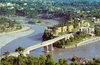
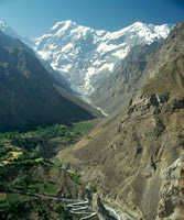
Hajira is a Tasil of Poonch district. Hajira is sorrounded by beautiful villages. Total Population of Hajira and sorrounded villages is almost Fourty Thousand(40,000). Line of Control ( Tatri Not Crassing Point) is only 5 Km far from Hajira city. There is a river ( Ranghar) passing from near to Bazar. There is alos a big Madrasa undercountrection, the Madrasa owner is Hazrat Pir Allao-ud-Din Sadiqi (Niarian Shareef). The weather of this city is hot in summer as compare to other Kashmir's citites.The special thing in hajira is that all hotel and resturant open 24 hours You can find a few hotel for stay. There is Degree college for boys and girls and as well as science model schools, and many other private schools. You can find a few hotel for stay. The people of this city is very polite and helpful.

MIRPUR AJK

Image
Mirpur district comprises partly plain and partly hilly areas. Its hot climate and other geographical conditions closely resemble those of Jhelum and Gujrat, the adjoining districts of Pakistan. The people of this area are basically farmers. Since the 1960s, a large number of people from this district have gone abroad , especially to the United Kingdom and the Middle East, for economic reasons. As such they are today the major foreign exchange earning source for Azad Kashmir and Pakistan. Around 50,000 people were moved from this district in the mid-sixties to make way for the construction of Mangla Dam. Most of these people settled in new Mirpur whilst some moved to Pakistan and the UK. Mirpur city is situated at 459m above sea-level and is linked with the main Peshawar-Lahore Grand Trunk road at Dina. The building of the new city in late sixties paved the way for new Mirpur situated on the banks of Mangla lake. The city was well planned and the buildings are mostly of modern design.

BAGH AJK

Image
Bagh was part of the Poonch province in the Dogra days. After 1947 it became a sub-division (Thesil) of the Poonch district only to become a district in its own right in 1988. Linked to Muzaffarabad by two roads, one via Sudhan Gali (80Km) and the other through Kohala (97Km). It is situated 46Km from Rawalakot . Bagh is well known for its confectionery and bakery products. Dhirkote is a facinating and charming place located 24Km from Kohala . Situated at 1676m above sea-level, Dhirkote possesses an extremely pleasant and healthy climate. The place is very popular among people mainly due to easy access, suitable altitude and beautiful landscape with Deodar and kail forests. Neela Butt is located 6Km from Dhirkote at an altitude of 2000m above sea-level. It was at this place on 23rd August 1947, the local rebels, aiming to get independence, met and made decisions about the liberation of Kashmir from Doga rule. Neela Butt is regarded as the birth-place of the independence movement and

MUZAFFARABAD AJK

Image
Muzaffarabad is situated at the confluence of the Jhelum and Neelum rivers and surrounded by majestic mountains and looks like a walled paradise. It is the administrative capital of Azad Kashmir. Behind the Secretariat to the east is a road climbing above the town from where one can walk up to Pir Chinasi located at 2,900 meters with breathtaking views of the Jhelum Valley and high mountain peaks just above the Neelum towards the North. From the cool on the Abbottabad Road, you can walk along the ridge looking over the Jhelum and Kunhar rivers. The city is a combination of old and new buildings and a blend of different cultures and languages. It has besides official buildings; farms, parks and historic forts standing on the banks of the Neelum, Muzaffarabad, Mirpur, Rawalakot and Kotli and are connected with the rest of Pakistan through Micro-wave telephony system. There are ample Rest houses, hotels and guesthouses in Muzaffarabad City where tourists can stay in comfort and enjoy t

KOTLI AJK

Image
The area now comprising district Kotli was a sub-division of Mirpur district up to the year 1975. Prior to 1947, it was a part of the Jammu area. Kotli is a hilly area rising gradually towards the high mountains of Poonch district. Its climate is more moderate than that of Mirpur due to the sub-mountaneous topography. The river Poonch passes through Kotli to be joined by a smaller river called the Baan at Brahli, a short distance from Kotli. The district headquarter is at a distance of 141Km from Islamabad (capital of Pakistan). It is linked with Mirpur by two metalled roads, one via Gulpur and Rajdhani, and the other via Dhungi and Charohi. It is also directly linked with Islamabad/Rawalpindi via Sehnsa and Holar. Kotli has basic facilities like a main bazaar, banks, hospitals, colleges, telephone and telegraph office and hotels. There are two theories about the origins of the name of Kotli . One school of thought claims that in ancient times, Prince Raja Shahswar Khan built a small

RAWALAKOT AJK

Image
Rawalakot is a city in Azad Kashmir, and is the capital of Poonch District. It is in a saucer-shaped valley at elevation 1615 metres (5300ft). It is 76 kilometres (47 miles) from Kohala, and is also linked with Rawalpindi and Islamabad via the neighbouring districts of Azad Pattan and Tain Dhalkot,and with Muzaffarabad via Kohala and Sudhangali by asphalt roads. The main tribe of Rawalakot are the Sudhan tribe. Rawalakot is the district headquarters and is situated in the heart of district Poonch . The altitude of this beautiful saucer-shaped valley is 1615m, and is situated 76 Km from Kohala. During summer, the place becomes full of green grass and beautiful flowers including many varieties of roses. Located 12Km from Rawalakot is Paniolla full of calm and charming characteristics. About 20Km from Rawalakot and at 1981m above sea-level is Banjosa. A very attractive site full of scenic beauty which also houses a small lake with boating facilities. Surrounding villages include Topa So

AZAD JAMMU & KASHMIR

Image
The State of Azad Kashmir (Liberated Kashmir), is part of the Pakistani administered section of the state of Jammu and Kashmir, along with the Northern Areas; its official name is Azad Jammu and Kashmir. It covers an area of 13,300 km² (5,135 mi²), with its capital at Muzaffarabad, and has an estimated population of almost 4 million people. Azad Kashmir has been considered politically, constitutionally and geographically as part of a separate state, i.e. Jammu & Kashmir . The said state is disputed territory and has been controlled by both Pakistan and India, since their independence, 14 / 15th August 1947, respectively. Azad Kashmir is under the indirect control of Pakistan and its area is known as Azad Jammu & Kashmir. Its defence, foreign policy and currency are the matters, which are under the direct control of Pakistan. Consequently, the financial matter, i.e. budget and tax affairs have been dealt with Azad Jammu & Kashmir Council, instead of Central Board of Revenue

Skardu & Deosai Plains (Baltistan)

Image
Capital of Baltistan is perched 2,438 metres above sea level in the backdrop of the great peaks of the Karakoram mountain range. Baltistan is known as the "Tibet-e-Khurd" or Little Tibet since its life-style reflects that of the roof of the World and Land of Lamas.It borders on the Chinese province of Xinjiang and Indian-occupied Kashmir. Places to Visit Apart from its incomparable cluster of mountain peaks and glaciers Baltistan's five valleys - Shigar, Skardu, Khaplu, Rondu and Kharmang are noted for their luscious peaches, apricots, apples and pears. Shigar valley, 32 kms by jeep from Skardu is the gateway to the mountain peaks of the Karakorams. Skardu has a historic Fort atop a ridge known as the Mindoq-Khar or Castle of Queen Mindoq and three lovely lakes. The two - Kachura Lake 29 kms and Stapra Lake 8 kms from Sakrdu are ideal for fishing. Deosai Plains: The Deosai Plains are 32 km south of Skardu. This plateau is the habitat of the greatly threatened Himalayan Br

Kaghan & Naran Valleys

Image
Kaghan valley is one of the prime tourist attractions of Pakistan. Stretched over 160 km, it is abound with snow-clad mountains, flowery meadows, enchanting lakes, and dense forests. With so much to offer, it provides an exhilarating experience; seeked after by thousands of tourists who flock the valley each year. The altitude of the valley ranges from 3000 ft above sea level to it's peak height of 13,690 ft at Babusar Pass. The principle river is the Kunar River which originates from the 11,300 ft Lulusar Lake. Apart from the scenic beauties on offer, the valley is also an attraction for Trout fishing, albeit with a permit. Journey time from the rest of the country to Gilgit and the Northern Areas can be reduced by as much as 4 hours if travelled via Kaghan valley via Babusar instead of the Karakuram Highway via Kohistan. Public transport on this route, however, is scarce and expensive. The valley is reachable from Abbottabad and Mansehra via the Karakuram Highway until it forks o

Chitral & Kafiristan (Kalash Valley)

Image
The Chitral Valley at an elevation of 1,128 metres, is favourite with mountaineers, anglers, hunters, hikers, naturalists and anthropologists. The 7,705 metres Trichmir, the highest peak of the Hindukush range, dominates this 322 kms long exotic valley. Location Chitral district has Afghanistan on its north, south and west. A narrow strip of Afghan territory, Wakhan, separates it from Tajikistan. The tourist season in Chitral is from June to September. The maximum temperature in June is 35 C and the minimum 19 C. In September the maximum is 24 C and minimum 8C. Attractions Kalash Valleys One of the major attractions of Chitral are the Kalash valleys - the home of the Kafir-Kalash or "Wearers of the Black Robes", a primitive pagan tribe. Their ancestry is enveloped in mystery and is the subject of controversy. A legend says that five soldiers of the legions of Alexander of Macedonia settled in Chitral and are the progenitors of the Kafir-Kalash.Over 3,000-strong Kafir-Ka

Gilgit & Hunza Valleys

Image
At an elevation of 1,454 metres lies the Gilgit Valley. The quaint little town of Gilgit has spectacular scenic beauty. The peak tourist season is from May to mid-October though the tourist season is round the year. The maximum temperature in May is 33 C and minimum 16 C. In September, Maximum 28 C and minimum 11C. Places of Interests: 10 kms from Gilgit town is a beautiful rock engraving of Buddha of 7th century A.D.at the mouth of the Kargah Nullah. A victory monument of Taj Mughal, built 700 years ago, is 30 kms. Jeep drive from Gilgit town. The bridge over the fast flowing Gilgit river is the largest suspension bridge in Asia (182 metres long and 2 metres wide) permitting enough room for one jeep at a time to cross. Activities in the area: The favourite sport in Gilgit is polo which local folks claim originated here. It's more rugged, free-style version than the sedate variety known in the plains. The polo tournament held from 1st November to 7th November is a festive occasion

SWAT VALLEY

Image
The Lush-green valley of Swat, with its rushing torrents, icy-cold lakes, fruit-laden orchards and flower-decked slopes is ideal for holiday-makers intent on relaxation. It has a rich historical past, too. This is "Udayana" (the "Garden") of the ancient Hindu epics; "the land of enthralling beauty" where Alexander of Macedonia fought and won some of his major battles before crossing over to the plains of Pakistan. This is "the valley of the hanging chains" described by the famous Chinese pilgrim-chroniclers, Huain Tsang and Fa-Hian in the fifth and sixth centuries. Swat was once the cradle of Buddhism of all its schools- Little Vehicle, Great Vehicle and the Esoteric sects where once 1,400 monasteries flourished. It was the home of the famous Gandhara School of Sculpture which was an expression of Graeco-Roman form in the local Buddhist tradition. Swat was also the historical land where the Muslim conquerors, Mahmud of Ghazni, Babur and Akbar fo

Northern Areas of Pakistan

Image
Northern Areas of Pakistan, spread over 72,496 sq. km are as fascinating as its southern region. Amidst towering snow-clad peaks with heights varying from 1,000 m to 8,000 meters, the regions of Gilgit, Hunza, Baltistan and Shangri-La. The cultural patterns of these regions are as interesting as its geography. The people with typical costumes, folk dances, music and sports like polo and buzkashi, provide the traveller an unforgettable experience. Out of 14 over 8,000 meters high peaks on earth, 4 occupy an amphitheater at the head of Baltoro glacier in the Karakoram range in Northern Pakistan. These are; K-2 or Mount Godowin Austin (8,611 m, world's second highest), Gasherbrum-I (8,068 m), Broad Peak (8,047 m) and Gasherbrum-II (8,035 m). There is yet another which is equally great, Nanga Parbat (8,126 m), located at the western most end of the Himalayas. In addition to these mountains, there are 68 peaks over 7,000 m and hundreds others of over 6,000 meters. The Northern Pakistan

HOTELS IN ISLAMABAD

ISLAMABAD: Islamabad Marriott Hotel Aga Khan Road Shalimar 5 P.O. Box 1251, Islamabad, Pakistan +92 51 2826121. _________________________________ SERENA HOTEL Ramna 5 Khayaban-e-Suhrawardy Islamabad Pakistan. (92) 51 287 4000 _________________________________ HOLIDAY INN G-6 Civic Centre Islamabad 44000 PakistanPhone: 92-51-111273273 _________________________________ Best Western Islamabad Hotel 6 Islamabad Club Road Islamabad Pakistan. _________________________________ Hotel Crown Plaza Pakistan's capital city center 99-e, Jinnah Avenue islamabad. _________________________________ Adventure Inn * Garden Ave, National Park Area, P.O.Box.1807 2272537 2274625 _________________________________ Best Regency * * 13, Kaghan Road, F-8/3 2857874 2261633 _________________________________ Best Western Hotel * 6-Islamabad Club Road 2277460 -2277467 2271539 _________________________________ Capital Inn * G-8, Markaz 2264680 2260980 _________________________________ Citi International * * Block

GWADAR

Image
Gwadar is located on the southwestern coast of Pakistan, on the Arabian Sea. It is strategically located between three increasingly important regions: the oil-rich Middle East, heavily populated Pakistan and the economically emerging and resource-laden region of Central Asia. The Gwadar Port was built on a turnkey basis by China and signifies an enlarging Chinese footprint in a critically important area. Opened in spring 2007 by then Pakistani military ruler General Pervez Musharraf, in the presence of Chinese Communications Minister Li Shenglin, Gwadar Port is now being expanded into a naval base with Chinese technical and financial assistance. Gwadar Port became operational in 2008, with the first ship to dock bringing 52000 tonnes of wheat from Canada. Minister of Ports and Shipping Sardar Nabil Ahmed Khan Gabol officially inaugurated the port on 21 December 2008. China has acknowledged that Gwadar’s strategic value is no less than that of the Karakoram Highway, which helped cement

JHELUM

Image
Jhelum or Jehlum is a city in northern Punjab Province, Jhelum District, Pakistan. Jhelum lies on the right bank of the Jhelum River. The 16th-century Grand Trunk Road passes through the city. According to the 1998 census of Pakistan the population of Jhelum was 293,000.The name of the city is derived from the words Jal (pure water) and Ham (snow), as the river that flows through the river originates in the Himalayas.There are numbers of industry in and around Jhelum city. Major industries include a tobacco factory, wood, marbel, glass and flour mills. History Jhelum is near the site of the famous Battle of the Hydaspes between the armies of Alexander the Great and Raja Porus This battle took place a few miles downstream from the city centre, along the river banks. The city was founded to commemorate the death of Alexander's horse, Bucephalus, and was originally called Bucephala. Nearby there is also the historic 16th century Rohtas Fort and Tilla Jogian. The main market area of th

SAHIWAL

Image
Sahiwal is a growing city in the southeastern province of Punjab province of Pakistan and the administrative centre of Sahiwal District. Sahiwal has become a division headquarters in 2008. The districts of Okara and Pakpattan are under Sahiwal division. This city was a small village on the Karachi-Lahore railway line in 1865 when it was renamed Montgomery after Sir Robert Montgomery, then Lieutenant-Governor of Punjab. It took its current name in 1966. Sahiwal lies approximately 180 km from the major city of Lahore. And it is the biggest city between Lahore and Multan. The population is 207,388 (1998 Pakistan Census. Sahiwal District is included in the former Multan Division and lies between 30-39 north latitude and 73-06 longitude. The people of Sahiwal are known as Sahiwalians. Climate The climate of Sahiwal district is extreme, reaching 52 °C in summer, and down to -5 °C in winter. The soil of the district is very fertile. The average rainfall is about 2000 mm. Industry Sahiwal'

TAXILA

Image
Taxila is an important archaeological site in the Punjab province of Pakistan. It dates back to the Ancient Indian period and contains the ruins of the Gandhāran city of Takshashila (also Takkasila or Taxila) an important Vedic/Hindu and Buddhist centre of learning from the 6th century BCE to the 5th century CE. In 1980, Taxila was declared a UNESCO World Heritage Site with multiple locations. Historically, Taxila lay at the crossroads of three major trade routes: the royal highway from the north-western route through Bactria, and (Peshawar); and the route from Kashmir and Central Asia, via Śrinigar, Mansehra, and the Haripur valley across the Khunjerab pass to the Silk Road. Taxila is situated about 32 km to the north-west of Islamabad Capital Territory—and Rawalpindi in Punjab—just off the Grand Trunk Road. Its elevation above the sea-level is 549 meters. Present day Taxila is one of the seven Tehsils (sub-district) of Rawalpindi District. It is spread over an undulating land in the

SIALKOT

Image
Sialkot is the capital of Sialkot District, is a city situated in the north-east of the Punjab province in Pakistan at the feet of the snow-covered peaks of Kashmir near the Chenab river. Formerly, Sialkot has been the winter-capital of the State of Kashmir. The city is about 125 km (78 mi) north-west of Lahore and only a few kilometres from Jammu in India. Geography and Climate: Lying between 32°30′ North latitude and 74°31′ East longitude at an altitude of 256 m above sea level, Sialkot is bounded on the north by Jammu, north-west by Gujrat, on the west by Gujranwala and on the south by Narowal. The Chenab river flows on the northern side of Sialkot. There are three small seasonal streams flowing through the city, Aik, Bher and Palkhu. Sialkot is cold during winters and hot and humid during summers. May and June are the hottest months. The temperature during winter may drop to 0°C. The land is, generally, plain and fertile. Most of the rain falls during the Monsoon season in summer w

GUJRANWALA

Image
Gujranwala is a city in Punjab, Pakistan with a population of 1,132,509 (1998 census).Gujranwala is located at 32.16° North, 74.18° East and is 226 metres (744 feet) above sea-level. With a population of over 1.1 million Gujranwala is the seventh largest city in Pakistan, and is one of Pakistan's most industrialised cities. It borders with Ghakhar Mandi and some small towns and villages. Punjabi is the local language, however English and Urdu are also common, particularly in schools and offices, as is the case in almost all of Pakistan. Transport Gujranwala Railway Station The Gujranwala Railway Station was Built by the British before the independence of Pakistan. It is situated on the Grand Trunk Road in the middle of the city. Highway Highway and river transportation. It has a dry port for the export of local products to the rest of the world. The nearest airport are the Allama Iqbal International Airport Lahore -80 km, and Sialkot International Airport, Sialkot- 40 km. Education