Posts

Showing posts from June, 2009

MIRPUR AJK

Image
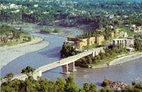
Mirpur district comprises partly plain and partly hilly areas. Its hot climate and other geographical conditions closely resemble those of Jhelum and Gujrat, the adjoining districts of Pakistan. The people of this area are basically farmers. Since the 1960s, a large number of people from this district have gone abroad , especially to the United Kingdom and the Middle East, for economic reasons. As such they are today the major foreign exchange earning source for Azad Kashmir and Pakistan. Around 50,000 people were moved from this district in the mid-sixties to make way for the construction of Mangla Dam. Most of these people settled in new Mirpur whilst some moved to Pakistan and the UK. Mirpur city is situated at 459m above sea-level and is linked with the main Peshawar-Lahore Grand Trunk road at Dina. The building of the new city in late sixties paved the way for new Mirpur situated on the banks of Mangla lake. The city was well planned and the buildings are mostly of modern design.

BAGH AJK

Image
Bagh was part of the Poonch province in the Dogra days. After 1947 it became a sub-division (Thesil) of the Poonch district only to become a district in its own right in 1988. Linked to Muzaffarabad by two roads, one via Sudhan Gali (80Km) and the other through Kohala (97Km). It is situated 46Km from Rawalakot . Bagh is well known for its confectionery and bakery products. Dhirkote is a facinating and charming place located 24Km from Kohala . Situated at 1676m above sea-level, Dhirkote possesses an extremely pleasant and healthy climate. The place is very popular among people mainly due to easy access, suitable altitude and beautiful landscape with Deodar and kail forests. Neela Butt is located 6Km from Dhirkote at an altitude of 2000m above sea-level. It was at this place on 23rd August 1947, the local rebels, aiming to get independence, met and made decisions about the liberation of Kashmir from Doga rule. Neela Butt is regarded as the birth-place of the independence movement and

MUZAFFARABAD AJK

Image
Muzaffarabad is situated at the confluence of the Jhelum and Neelum rivers and surrounded by majestic mountains and looks like a walled paradise. It is the administrative capital of Azad Kashmir. Behind the Secretariat to the east is a road climbing above the town from where one can walk up to Pir Chinasi located at 2,900 meters with breathtaking views of the Jhelum Valley and high mountain peaks just above the Neelum towards the North. From the cool on the Abbottabad Road, you can walk along the ridge looking over the Jhelum and Kunhar rivers. The city is a combination of old and new buildings and a blend of different cultures and languages. It has besides official buildings; farms, parks and historic forts standing on the banks of the Neelum, Muzaffarabad, Mirpur, Rawalakot and Kotli and are connected with the rest of Pakistan through Micro-wave telephony system. There are ample Rest houses, hotels and guesthouses in Muzaffarabad City where tourists can stay in comfort and enjoy t

KOTLI AJK

Image
The area now comprising district Kotli was a sub-division of Mirpur district up to the year 1975. Prior to 1947, it was a part of the Jammu area. Kotli is a hilly area rising gradually towards the high mountains of Poonch district. Its climate is more moderate than that of Mirpur due to the sub-mountaneous topography. The river Poonch passes through Kotli to be joined by a smaller river called the Baan at Brahli, a short distance from Kotli. The district headquarter is at a distance of 141Km from Islamabad (capital of Pakistan). It is linked with Mirpur by two metalled roads, one via Gulpur and Rajdhani, and the other via Dhungi and Charohi. It is also directly linked with Islamabad/Rawalpindi via Sehnsa and Holar. Kotli has basic facilities like a main bazaar, banks, hospitals, colleges, telephone and telegraph office and hotels. There are two theories about the origins of the name of Kotli . One school of thought claims that in ancient times, Prince Raja Shahswar Khan built a small

RAWALAKOT AJK

Image
Rawalakot is a city in Azad Kashmir, and is the capital of Poonch District. It is in a saucer-shaped valley at elevation 1615 metres (5300ft). It is 76 kilometres (47 miles) from Kohala, and is also linked with Rawalpindi and Islamabad via the neighbouring districts of Azad Pattan and Tain Dhalkot,and with Muzaffarabad via Kohala and Sudhangali by asphalt roads. The main tribe of Rawalakot are the Sudhan tribe. Rawalakot is the district headquarters and is situated in the heart of district Poonch . The altitude of this beautiful saucer-shaped valley is 1615m, and is situated 76 Km from Kohala. During summer, the place becomes full of green grass and beautiful flowers including many varieties of roses. Located 12Km from Rawalakot is Paniolla full of calm and charming characteristics. About 20Km from Rawalakot and at 1981m above sea-level is Banjosa. A very attractive site full of scenic beauty which also houses a small lake with boating facilities. Surrounding villages include Topa So